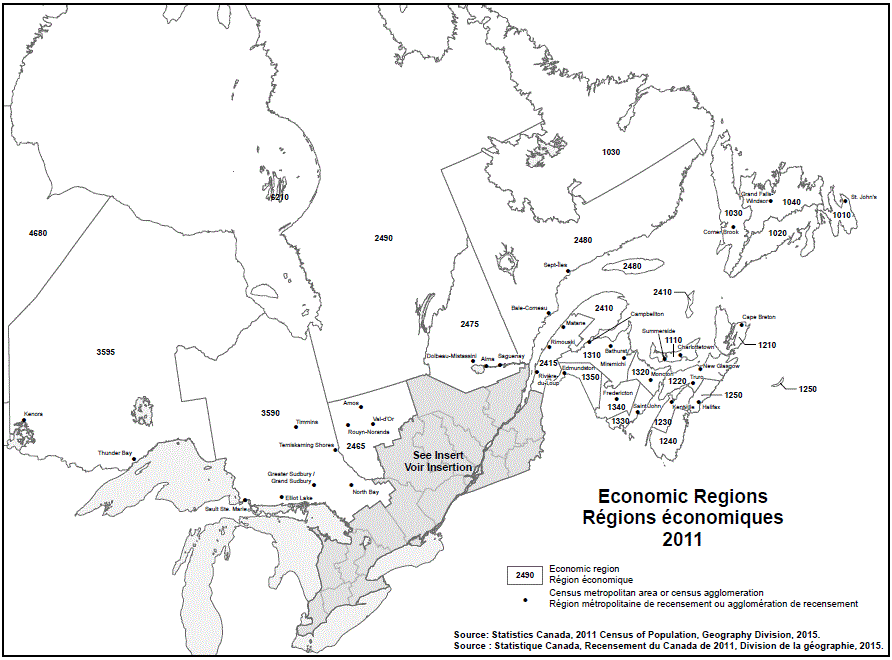
Geographical map of the 2011 Eastern Economic regions - map 1 of 2. See the table below for more detail on the names of the Economic regions, Census metropolitan areas (CMAs), and Census agglomerations (CAs) by province.
| Economic Region | CMA/CA |
|---|---|
| Avalon Peninsula (1010) | St. John's |
| South Coast–Burin Peninsula (1020) | Note ...: not applicable |
| West Coast–Northern Peninsula (1030) | Corner Brook |
| Notre Dame–Central Bonavista Bay (1040) | Grand Falls–Windsor |
| Economic Region | CMA/CA |
|---|---|
| Prince Edward Island (1110) | Charlottetown Summerside |
| Economic Region | CMA/CA |
|---|---|
| Cape Breton (1210) | Cape Breton |
| North Shore (1220) | New Glasgow Truro |
| Annapolis Valley (1230) | Kentville |
| Southern (1240) | Note ...: not applicable |
| Halifax (1250) | Halifax |
| Economic Region | CMA/CA |
|---|---|
| Campbellton–Miramichi (1310) | Bathurst Campbellton Miramichi |
| Moncton–Richibucto (1320) | Moncton |
| Saint John–St. Stephen (1330) | Saint John |
| Fredericton–Oromocto (1340) | Fredericton |
| Edmundston–Woodstock (1350) | Edmundston |
| Economic Region | CMA/CA |
|---|---|
| Gaspésie–Îles-de-la-Madeleine (2410) | Note ...: not applicable |
| Bas-Saint-Laurent (2415) | Matane Rimouski Rivière-du-Loup |
| Abitibi–Témiscamingue (2465) | Amos Rouyn-Noranda Val-d'Or |
| Saguenay–Lac-Saint-Jean (2475) | Alma Dolbeau-Mistassini Saguenay |
| Côte-Nord (2480) | Baie-Comeau Sept-Îles |
| Nord-du-Québec (2490) | Note ...: not applicable |
| Economic Region | CMA/CA |
|---|---|
| Northeast (3590) | Elliot Lake Greater Sudbury North Bay Sault Ste. Marie Temiskaming Shores Timmins |
| Northwest (3595) | Kenora Thunder Bay |
| Economic Region | CMA/CA |
|---|---|
| Northern (4680) | Note ...: not applicable |
Note: ... not applicable for this specific location.
Source: 2011 Census of Canada. Produced by the Geography Division, Statistics Canada, 2015.