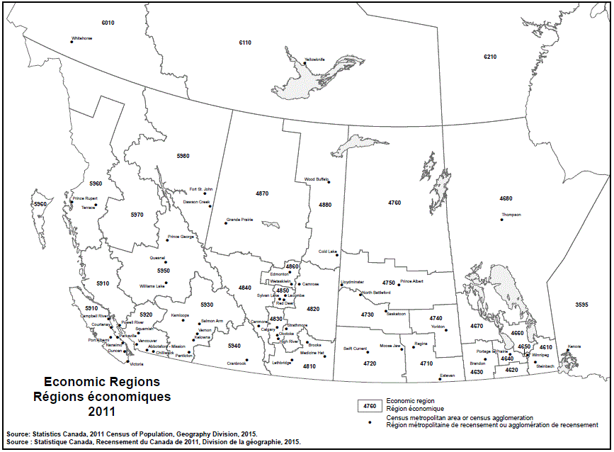
Geographical map of the 2011 Western Economic regions. See the table below for more detail on the names of the Economic regions, Census metropolitan areas (CMAs), and Census agglomerations (CAs) by province.
| Economic Region | CMA/CA |
|---|---|
| Northwest (3595) | Kenora |
| Economic Region | CMA/CA |
|---|---|
| Southeast (4610) | Steinbach |
| South Central (4620) | Note ...: not applicable |
| Southwest (4630) | Brandon |
| North Central (4640) | Portage la Prairie |
| Winnipeg (4650) | Winnipeg |
| Interlake (4660) | Note ...: not applicable |
| Parklands (4670) | Note ...: not applicable |
| North (4680) | Thompson |
| Economic Region | CMA/CA |
|---|---|
| Regina–Moose Mountain (4710) | Estevan Regina |
| Swift Current–Moose Jaw (4720) | Moose Jaw Swift Current |
| Saskatoon–Biggar (4730) | North Battleford Saskatoon |
| Yorkton–Melville (4740) | Yorkton |
| Prince Albert (4750) | Lloydminster Prince Albert |
| Northern (4760) | Note ...: not applicable |
| Economic Region | CMA/CA |
|---|---|
| Lethbridge–Medicine Hat (4810) | Brooks Lethbridge Medicine Hat |
| Camrose–Drumheller (4820) | Camrose Strathmore |
| Calgary (4830) | Calgary High River Okotoks |
| Banff–Jasper–Rocky Mountain House (4840) | Canmore |
| Red Deer (4850) | Lacombe Red Deer Sylvan Lake |
| Edmonton (4860) | Edmonton Wetaskiwin |
| Athabasca–Grande Prairie–Peace River (4870) | Grande Prairie |
| Wood Buffalo–Cold Lake (4880) | Cold Lake Wood Buffalo |
| Economic Region | CMA/CA |
|---|---|
| Vancouver Island and Coast (5910) | Campbell River Courtenay Duncan Nanaimo Parksville Port Alberni Powell River Victoria |
| Lower Mainland–Southwest (5920) | Abbotsford–Mission Chilliwack Squamish Vancouver |
| Thompson–Okanagan (5930) | Kamloops Kelowna Penticton Salmon Arm Vernon |
| Kootenay (5940) | Cranbrook |
| Cariboo (5950) | Prince George Quesnel Williams Lake |
| North Coast (5960) | Prince Rupert Terrace |
| Nechako (5970) | Note ...: not applicable |
| Northeast (5980) | Fort St. John Dawson Creek |
| Economic Region | CMA/CA |
|---|---|
| Yukon (6010) | Whitehorse |
| Northwest Territories (6110) | Yellowknife |
| Nunavut (6210) | Note ...: not applicable |
Note: ... not applicable for this specific location.
Source: 2011 Census of Canada. Produced by the Geography Division, Statistics Canada, 2015.