Geographical map of 2006 Census Metropolitan Area of Peterborough, Ontario

peterborough.jpg

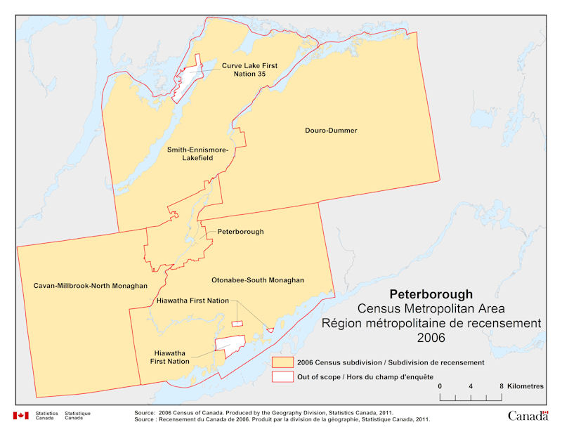
Geographical map of 2006 Census Metropolitan Area of Peterborough, Ontario. The following Census subdivisions and Out of scope are listed within this region:

Census subdivisions: Cavan-Millbrook-North Monaghan, Douro-Dummer, Otonabee-South Monaghan, Peterborough, Smith-Ennismore-Lakefield.

Out of scope: Curve Lake First Nation 35, Hiawatha First Nation.

Source: 2006 Census of Canada. Produced by the Geography Division, Statistics Canada, 2011.

Geographical map of 2006 Census Metropolitan Area of Moncton, New Brunswick

moncton.jpg

Geographical map of 2006 Census Metropolitan Area of Moncton, New Brunswick. The following Census subdivisions and Out of scope are listed within this region:

Census subdivisions: Coverdale, Dieppe, Dorchester, Elgin, Hillsborough, Memramcook, Moncton, Riverview, Saint-Paul, Salisbury.

Out of scope: Fort Folly 1

Source: 2006 Census of Canada. Produced by the Geography Division, Statistics Canada, 2011.

Geographical map of 2006 Census Metropolitan Area of Victoria, British Columbia

victoria.jpg

Geographical map of 2006 Census Metropolitan Area of Victoria, British Columbia. The following Census subdivisions and Out of scope are listed within this region:

Census subdivisions: Capital H (Part 1), Central Saanich, Colwood, Esquimalt, Highlands, Langford, Metchosin, North Saanich, Oak Bay, Saanich, Sidney, Sooke, Victoria, View Royal.

Out of scope: Becher Bay 1, Cole Bay 3, East Saanich 2, Esquimalt (R), New Songhees 1A, South Saanich 1, Sooke 1 (T’Sou-ke 1), Sooke 2 (T’Sou-ke 2), Union Bay 4.

Source: 2006 Census of Canada. Produced by the Geography Division, Statistics Canada, 2011.

Geographical map of 2006 Census Metropolitan Area of Vancouver, British Columbia

vancouver.jpg

Geographical map of 2006 Census Metropolitan Area of Vancouver, British Columbia. The following Census subdivisions and Out of scope are listed within this region:

Census subdivisions: Anmore, Belcarra, Bowen Island, Burnaby, Coquitlam, Delta, Greater Vancouver A, Langley, Lions Bay, Maple Ridge, New Westminster, North Vancouver, Pitt Meadows, Port Coquitlam, Port Moody, Richmond, Surrey, Vancouver, West Vancouver, White Rock.

Out of scope: Becher Bay 1, Cole Bay 3, East Saanich 2, Esquimalt (R), New Songhees 1A, South Saanich 1, Sooke 1 (T’Sou-ke 1), Sooke 2 (T’Sou-ke 2), Union Bay 4.

Source: 2006 Census of Canada. Produced by the Geography Division, Statistics Canada, 2011.

Geographical map of 2006 Census Metropolitan Area of Abbotsford-Mission, British Columbia

abbotsford_mission.jpg

Geographical map of 2006 Census Metropolitan Area of Abbotsford-Mission, British Columbia. The following Census subdivisions and Out of scope are listed within this region:

Census subdivisions: Abbotsford, Fraser Valley H, Mission.

Out of scope: Matsqui Main 2, Upper Sumas 6.

Source: 2006 Census of Canada. Produced by the Geography Division, Statistics Canada, 2011.

Geographical map of 2006 Census Metropolitan Area of Edmonton, Alberta

edmonton.jpg

Geographical map of 2006 Census Metropolitan Area of Edmonton, Alberta. The following Census subdivisions and Out of scope are listed within this region:

Census subdivisions: Beaumont, Betula Beach, Bon Accord, Bruderheim, Calmar, Devon, Edmonton, Fort Saskatchewan, Gibbons, Golden Days, Itaska Beach, Kapasiwin, Lakeview, Leduc, Leduc County, Legal, Morinville, New Sarepta, Parkland County, Point Alison, Redwater, Seba Beach, Spring Lake, Spruce Grove, St. Albert, Stony Plain, Strathcona County, Sturgeon County, Sundance Beach, Thorsby, Wabamun, Warburg.

Out of scope: Alexander 134, Stony Plain 135, Wabamun 133A, Wabamun 133B.

Source: 2006 Census of Canada. Produced by the Geography Division, Statistics Canada, 2011.

Geographical map of 2006 Census Metropolitan Area of Calgary, Alberta

calgary.jpg

Geographical map of 2006 Census Metropolitan Area of Calgary, Alberta. The following Census subdivisions and Out of scope are listed within this region:

Census subdivisions: Airdrie, Beiseker, Calgary, Chestermere, Cochrane, Crossfield, Irricana, Rocky View No. 44.

Out of scope: Sarcee 145 (Tsuu T'ina Nation 145).

Source: 2006 Census of Canada. Produced by the Geography Division, Statistics Canada, 2011.