Geographical map of 2006 Census Metropolitan Area of Saskatoon, Saskatchewan

saskatoon.jpg

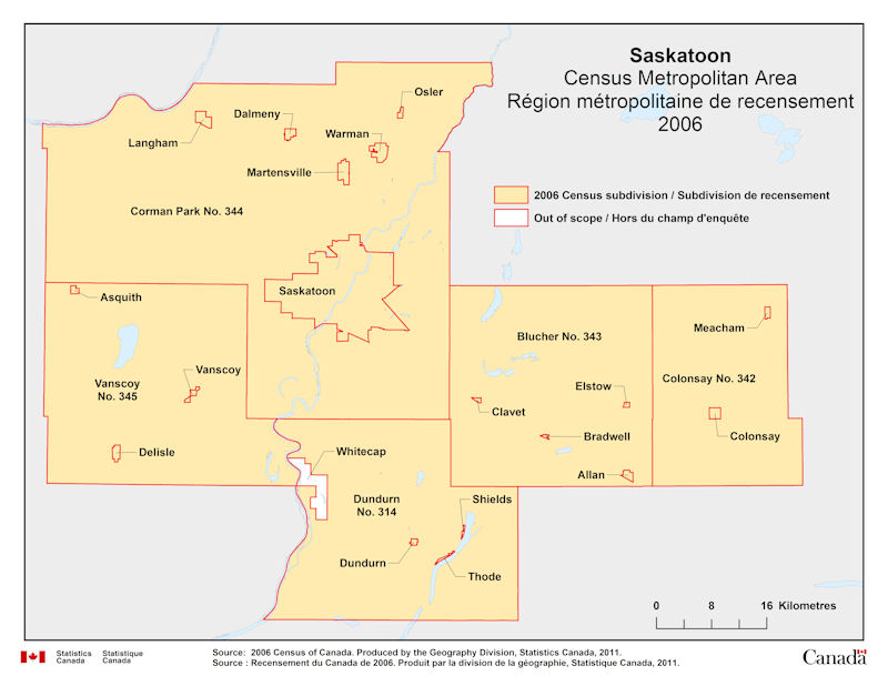
Geographical map of 2006 Census Metropolitan Area of Saskatoon, Saskatchewan. The following Census subdivisions and Out of scope are listed within this region:

Census subdivisions: Allan, Asquith, Blucher No. 343, Bradwell, Clavet, Colonsay, Colonsay No. 342, Corman Park No. 344, Dalmeny, Delisle, Dundurn, Dundurn No. 314, Elstow, Langham, Martensville, Meacham, Osler, Saskatoon, Shields, Thode, Vanscoy, Vanscoy No. 345, Warman.

Out of scope: Whitecap.

Source: 2006 Census of Canada. Produced by the Geography Division, Statistics Canada, 2011.

Geographical map of 2006 Census Metropolitan Area of Regina, Saskatchewan

regina.jpg

Geographical map of 2006 Census Metropolitan Area of Regina, Saskatchewan. The following Census subdivisions are listed within this region: Balgonie, Belle Plaine, Buena Vista, Disley, Edenwold, Edenwold No. 158, Grand Coulee, Lumsden, Lumsden Beach, Lumsden No. 189, Pense, Pense No. 160, Pilot Butte, Regina, Regina Beach, Sherwood No. 159, White City.

Source: 2006 Census of Canada. Produced by the Geography Division, Statistics Canada, 2011.

Geographical map of 2006 Census Metropolitan Area of Winnipeg, Manitoba

winnipeg.jpg

Geographical map of 2006 Census Metropolitan Area of Winnipeg, Manitoba. The following Census subdivisions and Out of scope are listed within this region:

Census subdivisions: East St. Paul, Headingley, Macdonald, Ritchot, Rosser, Springfield, St. Clements, St. François Xavier, Taché, West St. Paul, Winnipeg.

Out of scope: Brokenhead 4.

Source: 2006 Census of Canada. Produced by the Geography Division, Statistics Canada, 2011.

Geographical map of 2006 Census Metropolitan Area of Toronto, Ontario

toronto.jpg

Geographical map of 2006 Census Metropolitan Area of Toronto, Ontario. The following Census subdivisions and Out of scope are listed within this region:

Census subdivisions: Ajax, Aurora, Bradford West Gwillimbury, Brampton, Caledon, East Gwillimbury, Georgina, Halton Hills, King, Markham, Milton, Mississauga, Mono, New Tecumseth, Newmarket, Oakville, Orangeville, Pickering, Richmond Hill, Toronto, Uxbridge, Vaughan, Whitchurch-Stouffville.

Out of scope: Chippewas of Georgina Island First Nation.

Source: 2006 Census of Canada. Produced by the Geography Division, Statistics Canada, 2011.

Geographical map of 2006 Census Metropolitan Area of Thunder Bay, Ontario

thunderbay.jpg

Geographical map of 2006 Census Metropolitan Area of Thunder Bay, Ontario. The following Census subdivisions and Out of scope are listed within this region:

Census subdivisions: Conmee, Gillies, Neebing, O’Connor, Oliver Paipoonge, Shuniah, Thunder Bay.

Out of scope: Fort Williams 52.

Source: 2006 Census of Canada. Produced by the Geography Division, Statistics Canada, 2011.

Geographical map of 2006 Census Metropolitan Area of Greater Sudbury, Ontario

greatersudbury.jpg

Geographical map of 2006 Census Metropolitan Area of Greater Sudbury, Ontario. The following Census subdivisions and Out of scope are listed within this region:

Census subdivisions: Greater Sudbury.

Out of scope: Wahnapitei 11, Whitefish Lake 6.

Source: 2006 Census of Canada. Produced by the Geography Division, Statistics Canada, 2011.

Geographical map of 2006 Census Metropolitan Area of St. Catharines - Niagara, Ontario

stcatharines_niagara.jpg

Geographical map of 2006 Census Metropolitan Area of St. Catharines - Niagara, Ontario. The following Census subdivisions are listed within this region: Fort Erie, Lincoln, Niagara Falls, Niagara-on-the-Lake, Pelham, Port Colborne, St. Catharines, Thorold, Wainfleet, Welland.

Source: 2006 Census of Canada. Produced by the Geography Division, Statistics Canada, 2011.

Geographical map of 2006 Census Metropolitan Area of London, Ontario

london.jpg

Geographical map of 2006 Census Metropolitan Area of London, Ontario. The following Census subdivisions are listed within this region: Adelaine Metcalfe, Central Elgin, London, Middlesex Centre, Southwold, St. Thomas, Strathroy-Caradoc, Thames Centre.

Source: 2006 Census of Canada. Produced by the Geography Division, Statistics Canada, 2011.